(17th March 2013 – 17 miles walk from Stonethwaite in Borrowdale to Patterdale)
At seventeen miles and with two 2000ft mountain passes, Day 3 of the Coast to Coast was always going to be a challenge. I had walked the same route before but not in one day and not with such a heavy pack. Even so, I thought that as long as the weather wasn’t too unkind, it would be OK. Tiring sure but OK.
It was a blow then that instead of waking up to the usual rain of the previous two days, I pulled back the curtains at my B&B, blinked, shook my head and blinked again. It was snowing. (Not for the last time). It wasn’t meant to snow; snow hadn’t been forecast but yep, it most certainly was snowing.

Normally I love snow but not today. A thin layer on the valley bottom would probably be deeper up on high. And so it proved – today would be the hardest of my walk across England. Though others would come close.

After a fine cooked breakfast, I thanked the owner for her hospitality and said how much I had enjoyed my stay. “Yes, you’ve been OK too,” she replied. Faint praise or Cumbrian understatement? I like to think the latter but whatever, it made me laugh. Her concern at the weather, the distance and the climbs ahead of me was real enough.

Pat (the other Coast to Coaster whom I was to meet the following night) completed this section by car. His B&B owner had warned him against walking the fells in these conditions. Had I received the same advice, I might have caught the bus.

But I doubt it. I had planned this trip for months and, short of recklessness, meant to complete it. Besides, the landscape looked stunning and besides how bad could it be? (Er … well … pretty bad actually).
From the village, the path follows Stonethwaite Beck toward Eagle Crag. Here I saw my second red squirrel.

He was gone in a flash but I got a quick snap (if not a good one). I have now seen three red squirrels; all in the Lake District if in different valleys: Ennerdale, Borrowdale and Grisedale. If you see one in the Lakes, do report your sighting on the Red Squirrel Northern England Society website.

That great slab of rock dead ahead is Eagle Crag (1706 feet) but thankfully the path skirts round it and up the valley on the left.
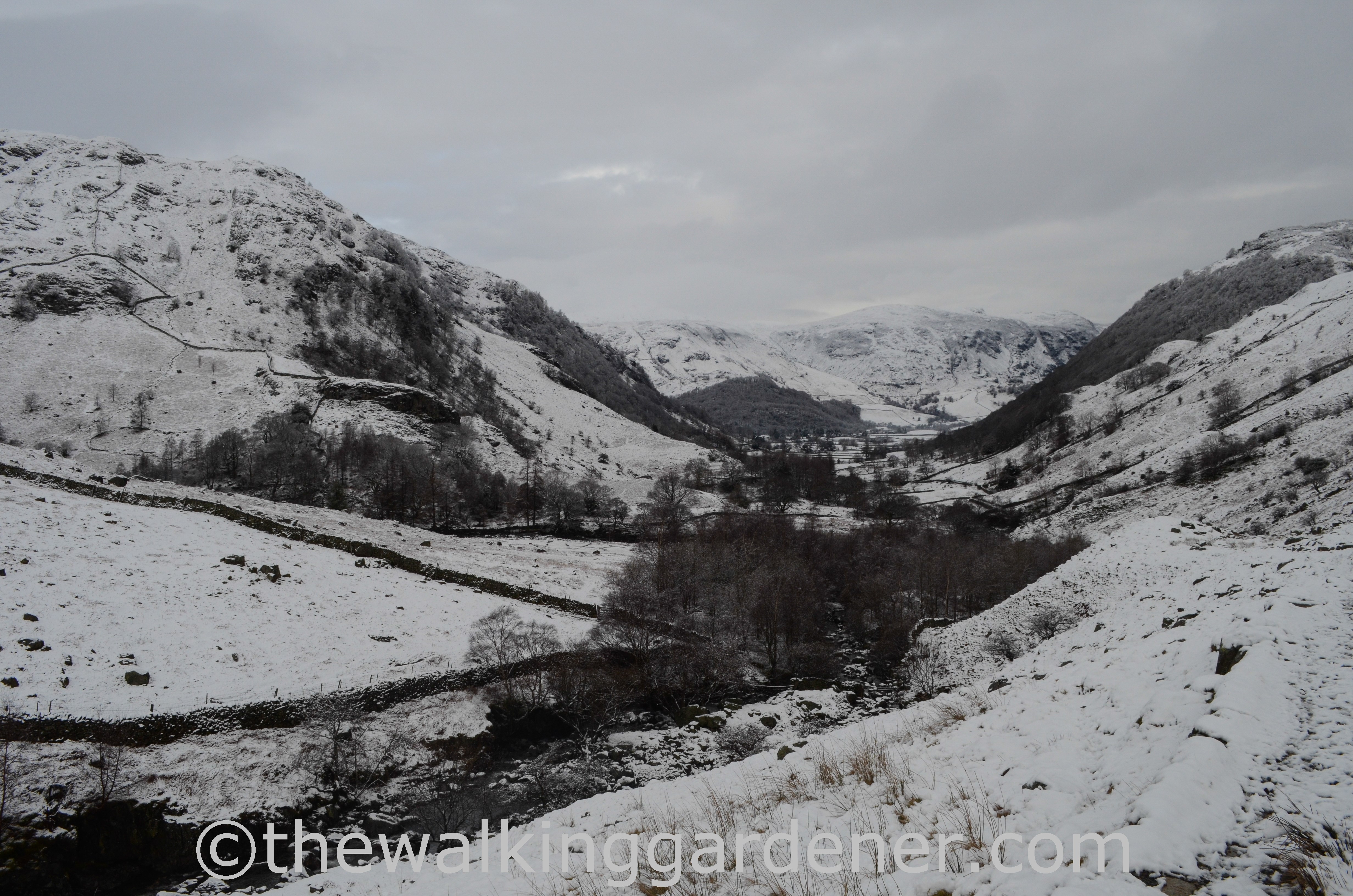
Today was a Sunday morning and I thought there would be plenty of walkers about but I didn’t see nor hear anyone; indeed I met no-one for several hours.

Even so, there were still moments of total gridlock on the path.

As I climbed higher, the snow got deeper;

the going harder and slower and more tiring. And running ahead to set up my camera’s self-timer before running back into shot tired me out more.

At the top of the initial climb beside Eagle Crag is a shallow basin filled with more glacial drumlins. The snow here was deep enough to obscure the path and there were no footprints to follow.

From above and behind, Eagle Crag didn’t look as high nor impressive. I had wanted to stand on its peak but thought I’d better press on.

A second steep effort up snow-hidden, mostly invisible steps carried me to the top of Lining Crag (1778 feet).

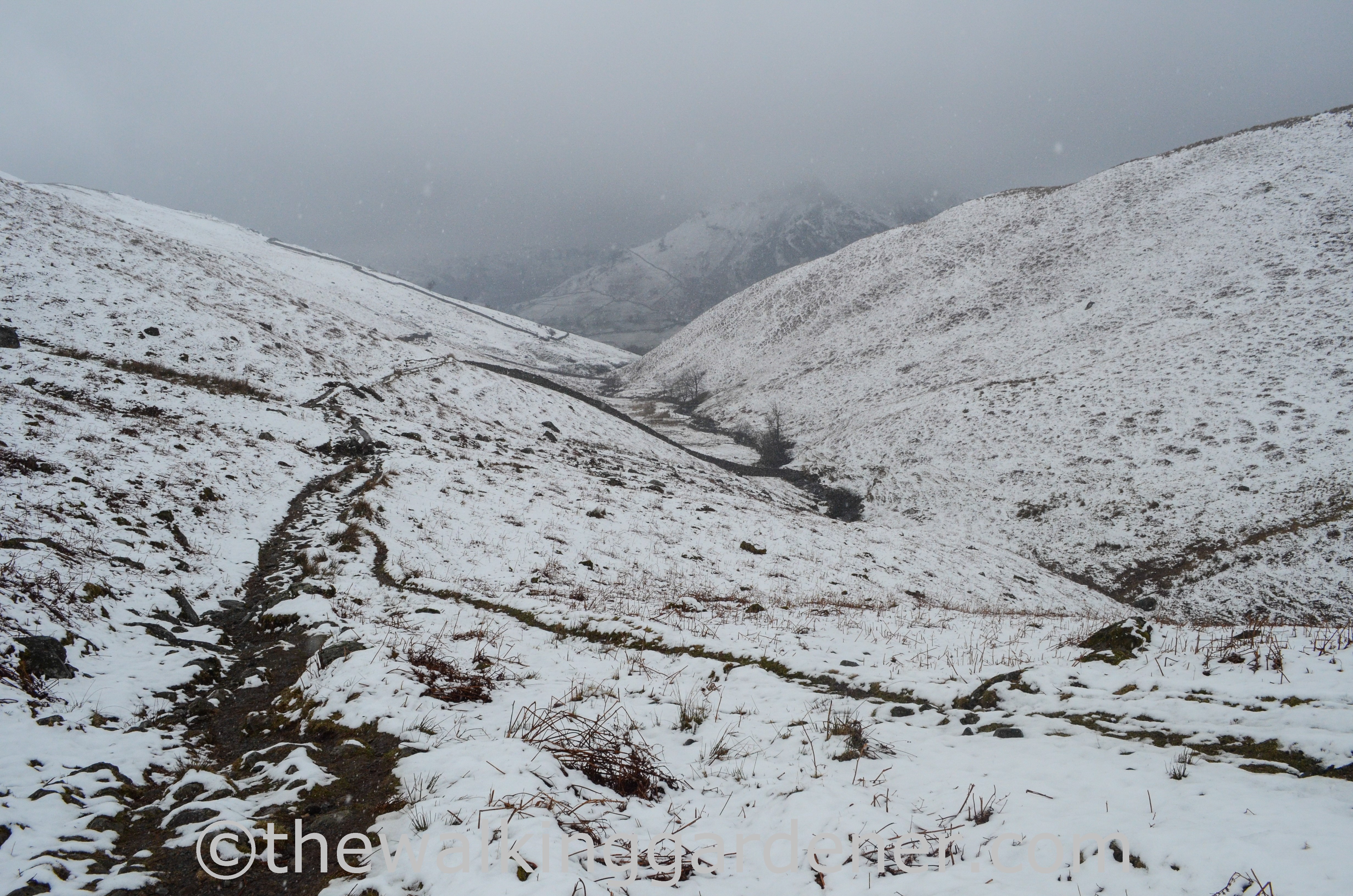
Despite the low cloud, visibility was pretty good and I began to hope that the day might clear. But shortly after I took the above photo, the cloud rushed in and it started snowing. (Not for the last time). My world shrunk to a thirty-yard radius.
The rest of the climb to the top of Greenup Edge (2000 feet) isn’t so straightforward in clear conditions – but the path was now completely smothered and the way forward uncertain.

My Trailblazer guidebook told me to follow a line of cairns … but was short on advice if these were practically invisible. I have hiked over Greenup Edge three times – and twice now in poor visibility when route-finding is bewildering. The map in my guidebook was of no help. It showed simply a broken line on white with virtually no detail. When a large rock formation loomed out of the mist, it was my Ordnance Survey map which told me that I had drifted too far to the South West. Using my compass, I regained the correct course – if not the actual path. This was a hairy time. Trailblazer said to aim for a “prominent fencepost on top of outcrop” but I failed to find it. If you have walked to Grasmere in fine weather and with the village visible in the far distance, it is difficult to appreciate how tricky navigation can be up here.
It was slow, sapping work. Muttering and cursing, I waded knee-deep across snow-fields; backtracked to avoid steep-sided gullies and uncross-able streams. All the time peering into the white gloom for a glimpse of a feature (any feature would’ve been nice) with which to confirm my position. On and on it went and I just hoped I was en route.

I was. Eventually, mightily relieved, I reached the head of Easedale and the start of the descent to Grasmere. Phew. I hurried on.

After a detour into the village for supplies, I stomped back northwards towards the second climb of the day. Sadly, I didn’t have time to accept the above invitation. It was nearly 2 o’clock and I still had a long way to go.

I began to climb again: Grisedale Hause at 1929 feet blocked me from my bed.

My spirits were low as I wearily headed back into cloud, rather wishing that I’d booked a B&B in Grasmere and not Patterdale.
Climbing steadily by Great Tongue, my breathless pauses became more frequent as the views closed in once again. And as I traversed the wide depression of Hause Moss, it began to snow. I was once more in a white-out with the path indiscernible and for the second time that day I became disoriented. I had thought the direction obvious, allowed my mind to wander and, idiotically, hadn’t bothered to use my compass. But then, I came across fresh footprints! Someone else was up here! Someone who probably knew where the hell they were going! Probably a proper walker and not some bumbling buffoon like me! Only slowly, as I walked beside them, did it dawn on me that I had somehow managed to complete a big circle and, Robinson Crusoe like, was now following my own footprints. Good grief, what a fool. I swore at my stupidity and finally dug out my compass.

I was beat: sweaty, absolutely shattered and beginning to worry that I would never find the top of the pass. Following a compass heading, I floundered up an endless, thigh-deep and very steep snow bank. At the top, I almost wept. There at my feet was the tumble-down dry stone wall I had been searching for. I was at the top of the pass. Higher up to the right of the actual path but a sweet, cherished moment nonetheless. I have never been so very grateful to see a tumble-down dry stone wall. Have you? I almost kissed it.

Scrambling down the far side, I didn’t see Grisedale Tarn until I almost stepped on it.

As I rejoined the path and skirted the tarn, the visibility began to clear and, now that I was on a path I’d walked before, I found my bearings.

I began the descent into Grisedale. Unbelievably for a weekend and on such a well used path – not only for the C2C but also for several nearby peaks – there were still no footprints.

The sun broke through and lit up the way ahead. I had thought that I would include a climb of St Sunday Crag (2759 feet) today. Ha!

This mountain, which I had climbed the previous November, marched along on my right as I dropped down toward Patterdale.

At the top of the pass, I had been totally immersed in snow, surrounded and hidden and hindered by snow. And yet now I could see how localised it had been – it didn’t even reach the valley floor.

At Ruthwaite Lodge climbing hut, I sat on a chunk of wood and ate half a pork pie and gulped mountain-cold water – my first rest since Grasmere.

It was getting dark as I reached my Bed and Breakfast at 5.45.
I had been walking for almost ten hours but after a shower and change of clothes, I started to walk again. Using my head torch in the dark, I walked the mile down to the White Lion pub in Patterdale for food and ale. And then more ale. And possibly another. After the day’s exertions I needed to steady my nerves.
I was bushed. I had completed the toughest day of my trip and probably my hardest day’s walk of my life. But I was well aware that tomorrow I had 16 miles to cover, including a climb to the highest point of the C2C: Kidsty Pike at 2559 feet.
Though I could have done with one, tomorrow would be no rest day. Actually, tomorrow didn’t turn out to be the day I was expecting at all.

Yes I echo the comments above David that you are definitely nuts. However you must be in great shape to achieve finishing in snowy conditions on the way to Patterdale. I notice that you were carrying a heavy backpack too. No Sherpa or anything like that in March I suppose. Trusting you will never do it again in March? Yes/no? I have done the c2c broken up in to four sections. I doubt if I will ever do it again….
LikeLike
Hi Guy, I also thought I’d never walk the C2C again after THAT walk but actually, looking back now, I can see me doing it again (but I’d split the Borrowdale-Patterdale stage in two, I think). It was a tough walk but I look back at it now a little wistfully. And yep, I’d consider March again. After all mine on the C2C was the worst in 60 years! I walked further the following March and had generally fantastic weather. I haven’t used a baggage transfer company before (though they are looking increasingly attractive the older I get) but you’re right – they don’t tend to operate early in the year. Happily nuts, David
LikeLike
You’re nuts! Sounds like you needed crampons! And one of those big dogs with a barrel of booze slung round his neck to follow close behind and offer refreshments…
LikeLike
I did have crampon-lites (yaktrax) but actually there wasn’t any ice to speak of. Snowshoes on the other hand might have been handy …. and a husky or two. I shall wear my ‘You’re Nuts’ badge with pride. D
LikeLike
Hello Stacy, yes a forehead-slapping shocker, especially as part of the circle climbed steeply – which I then had to do again. It was my own fault for not concentrating and being complacent – foolish in those conditions. You can be traipsing along in thick cloud, deep in thought when the cloud will momentarily lift (not on that day!) and remind you that the scenery is indeed amazing – even if it is mostly invisible. Dave
LikeLike
Good heavens, Dave. What a day — that Robinson Crusoe moment must have been a shocker. Good thing you had warm words of praise from the landlady to carry you through. I can see what draws you back to the area even in the depths of winter (other than not wanting to share the path, of course) — that’s amazing, dramatic scenery even when you can’t see the views!
LikeLike
Hehe. Lightweight, fair-weather walker! Afternoon tea indeed. We get to meet you after the next thrilling installment! D
LikeLike
The car and afternoon tea at Inn on the Lake was definitely the right decision after reading through this!
LikeLike